Sunday 4 December 2016

"Look, Don't Pick" - The Arguments

Over the months since the Forestry Commission announced their "Look, Don't Pick" Policy for Fungi on The New Forest SSSI on the Crown Lands under their stewardship, we've heard a number of arguments against this move.  The NFA support the Forestry Commission's policy as an important step to honouring the protections the habitat of the New Forest has, and ought to have in practice.  In that spirit we offer our rebuttals below:

Foraging is wonderful and magically connects people to nature.

Fine, just not fungi + here, please.

The New Forest is amongst the most highly protected habitat we have.  Would you challenge the existing prohibitions on fungi foraging on Wildlife Trust or National Trust land? The New Forest SSSI has the status of a National Nature Reserve. 

We could quibble that you shouldn't need to ingest nature to enjoy and appreciate it, but then again Chris Packham once said he started his journey eating tadpoles he'd found.  No accounting for tastes. Foraging can foster a relationship for many with nature, but this is a protected habitat, we're just asking those who actually care about nature, to respect its protection and find their fungi elsewhere.

We've done this for thousands of years (Entitlement vs loss of habitat)

You speak of what's been done for "thousands of years", that includes loads of behaviours that are no longer appropriate in the face of unprecedented population growth, habitat loss and climate change.  Butterfly collectors once showed their appreciation of Lepidoptera by popping them in killing jars then mounting them on pins. 

More than one in ten UK species is now threatened with extinction.  The house is burning, and you're concerned with raiding the larder.

Where is your proof of the so-called gangs? (Denial)

They and their effects have been seen  by the Forestry Commission Keepers and Ecologists, the National Trust Rangers, the Hampshire Fungi Recording Group, other local surveyors, and many of our members.  Last Autumn the Forestry Commission intercepted 140 groups and/or individuals as part of their "disruption" campaign, seizing and destroying amounts over the then "personal" limit.

You'll forgive us if those of us out walking don't whip out our cameras and ask strangers engaged in illegal activities to pose nicely to satisfy your curiosity.  Or that we haven't photographed every square fungi populated inch of the Forest ahead of time so that when it is subsequently stripped of fungi we could provide a before and after (hopefully recorded at exactly the same angle for the before and after).  The experiences and observations of many individuals, seem to count for nothing to those in denial. 

If you are that sceptical would a photo of a group of people holding bags in a wood convince you of anything? Or before and after pictures? If the FC put wildlife monitoring cameras by some patches of rare fungi, that would be rightly deemed too big brother (although police have said a private land owner doing this to catch similar acts would be perfectly legal).

You are criminalising ordinary people. 

Similar bans already exist, the inclusive language of the Epping Forest byelaws have allowed the Keepers employed by the Corporation of the City of London to enforce its policy against fungi forage.  Meanwhile the CROW Act which opened up larger areas of countryside to Ramblers has an overarching ban on foraging on the nationwide network of Rights of Way, and the Right to Roam areas.

This is a SSSI, the FC already had the right to authorise picking of fungi under the consents they have from Natural England.  Their byelaws ban removal of a range of things that are not currently enforced, and it is only a trick of taxonomy that fungi are excluded (FC byelaws prohibit: dig up, remove, cut or injure any tree, shrub or plant, whether living or not, or remove the seeds therefrom, or dig up or remove any soil, turf, leafmould, moss, peat, gravel, slag, sands or minerals of any kind).  It is as much a policy decision to choose not to enforce all the elements of the byelaws as to restrict fungi foraging under their SSSI consents and the precautionary principle to protect the entire habitat.

The Wildlife and Countryside Act 1981 is the legislative instrument that defines the protections for wild animals and plants and defines Sites of Special Scientific Interest along with their extra protections and the statutory obligations of their landowners.  Rare species found on the Schedule 8 list, often referred to as the Red Band or Red List Species, are protected from being picked, uprooted or destroyed (section 13 subsection 1), and further from being sold, transported for sale, or even advertised for sale (subsection 2).  These are arrestable offences, the CPS guidance for prosecutions :

Most offences are punishable on summary conviction by six month's imprisonment and/or by a maximum fine of £5,000 (level 5). Where an offence is committed in respect of more than one bird, nest, egg etc the maximum fine shall be determined as if the person had been convicted of a separate offence in respect of each such item.

In addition to offences being multiplied by number of items taken, the law also gives power of forfeiture:


Under s.21 (6) b a court may in the same circumstances order the forfeiture of any vehicle, animal, weapon or other thing used to commit the offence found in the offender's possession. Forfeiture of a vehicle is often likely to be an effective means of deterring repeat offences relating, for example, to rare birds and eggs as well as of incapacitating an offender's future ability to conduct such activities. ....

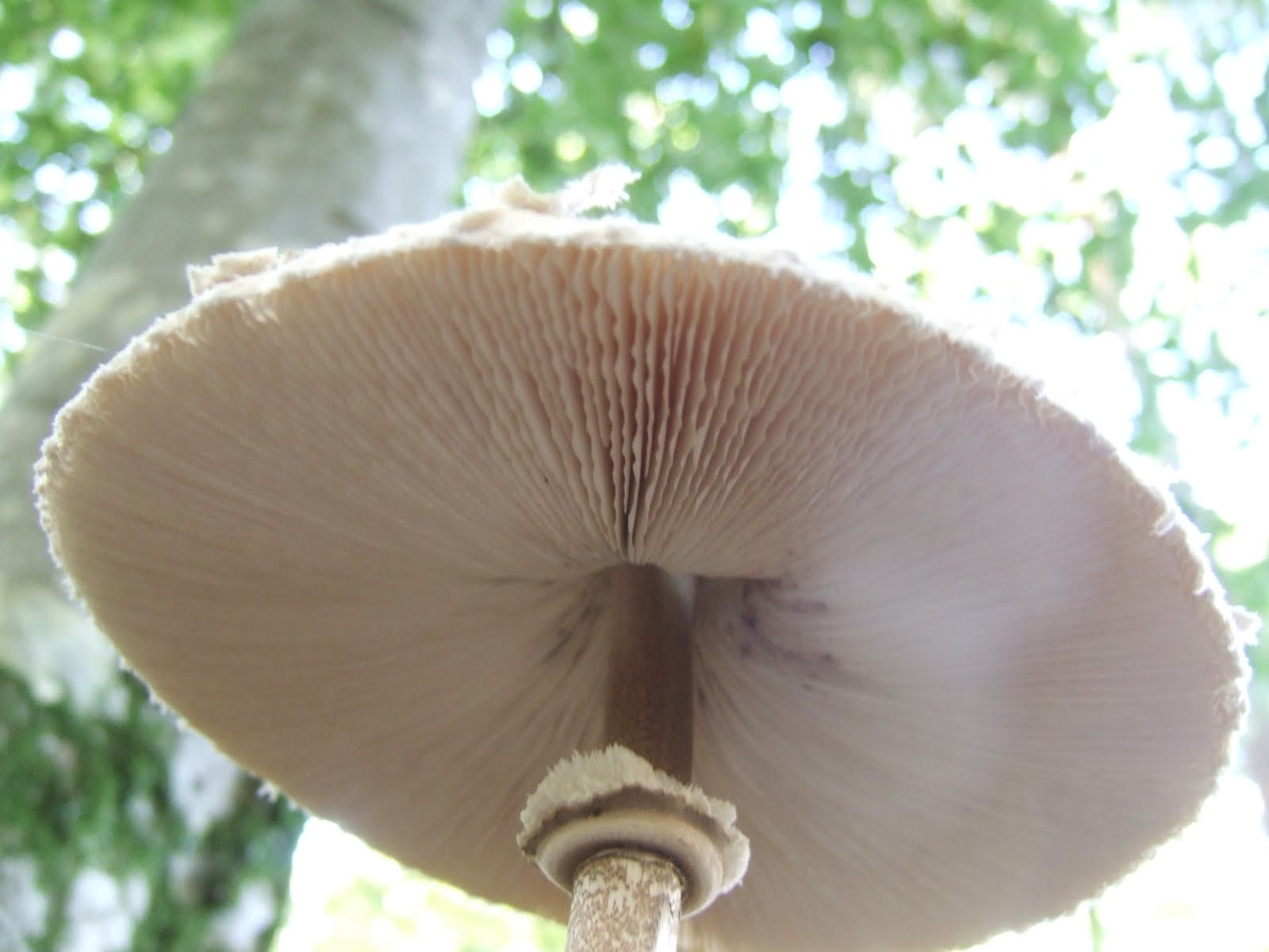
The section 13 protections apply ANYWHERE in the Wild, not just SSSI.  The Red List includes fungi species such as the tasty, targeted and allegedly medicinal Hericium erinaceus (bearded tooth).

Hericium erinaceum on an old tree in Shave Wood, New Forest - geograph.org.uk - 254892
Hericium erinaceus in the New Forest
On SSSI's intentionally or recklessly destroying or damaging flora or fauna by reason of which land is of special interest is an offence under the Wildlife and Countryside Act 1981 Section 28 (P).   The New Forest is one of the few SSSI which have fungi as one of these notified features of special interest. Whether or not the fungi harvested is one of the notified species, the ancillary consequences of the activity of foraging, including trampling and disturbance may be covered by this as well. Hefty penalties invoked here may give prosecutions considerable bite.  Damage to SSSI could be prosecuted, and yield realistically punitive fines (£10k-20k).  Of course the burden of proof is less straightforward than the section 13 offences, but I'm describing this to show the extent to which some fungi foraging activities were already criminal, and the legal basis which obligates the Forestry Commission to protect the notified features of the SSSI it manages.

This is Common Land - don't we have the right to forage from it as part of rights of Common?

The Crown Lands are not actually registered commons as applies under the Commons Registrations Act, and so would not implicitly include any rights that may be extended to registered commons either under that act or in common law.

The modern legal framework for the Forest rights as applied to the New Forest are in the New Forest Acts which clearly defines rights of Common for the Crown Lands, these 1) don't include Foraging 2) can only can be claimed by those occupying land with registered rights attached.

The ban is not scientific, because we have studies that show that harvesting fruiting bodies doesn't have a detrimental effect.  (Selective research)

Compared to botany, mycology is positively medieval.  Not enough is known. We're only just now coming to appreciate the complexity of the relationship between mycorrhizal fungi and the trees they service symbiotically.

There are only have a handful of studies on a few species, some not in comparable locations/habitats, that show negligible effect on individual fungi organisms of picking fruiting bodies, but not much on the long term viability of a given species and genetic diversity over time given the disruption to dispersal mechanisms. 

These studies do not consider the knock on effects on the rest of the ecosystem, putting aside the fruiting bodies as a food source, at least 600 (likely over 1000) species of invertebrate are reliant on them for their life-cycle (many are species specific).  Committed eggs don't have the luxury of jumping to unpicked neighbours.  There are no studies showing ancillary effects on the rest of the ecosystem, therefore no substantial body of evidence for sustainability. 

Furthermore, the "sustainability" argument shouldn't even apply on a SSSI with fungi as one of its notified features.  An attitude that recognises only supporting science in isolation, claims an absent weight of evidence, and ignores the bigger picture, is utterly self-serving.

Europe is a free for all. 


This is simply not true.  France and Spain have no go areas.  There are licensing schemes in Italy and Poland and other eastern European Countries.  It is unlikely you would be allowed to pick fungi at all in Poland's National Parks which include Strict Protection Zones, no go areas for any human interaction -- reasons given include fungi conservation along with other habitat considerations, some parks even have buffer zones excluding people from an area outside the park.  Other European countries have similarly strict regimes if they have signed up to the level of habitat protection promoted by the IUCN and the Biosphere initiative.

Just because European cultures supposedly favour a tradition of fungi forage doesn't mean they are blind to the need for conservation.  The Crown Lands of the New Forest have the highest levels of habitat and landscape protections and designations available in UK law.

And Finally, that old, ahem, chestnut: It's just like picking Blackberries!

NO IT ISN'T (sorry for shouting):

  • Blackberry population is much greater and currently sustainable.
  • Blackberry pickers take only the fruit, not the entire visible portion of the plant.  In the protected landscape of a National Park the autumn display of fungi should be left for all to see.
  • Blackberry fruits are only harvested by pickers when they are ripe, they may be eaten by wildlife before this, and when pickers miss the optimal ripeness opportunity, after. Fungi are being removed when they are seen, not left for an optimal ripening.  If picked when still at "button" stage, they have not released spores.
  • The seeds in blackberry fruit are part of its distribution mechanism, the amount left unpicked, and fed upon by wildlife sustainably spreads the next generation.  Fungi fruiting bodies contain spores that go unreleased if they are picked, and may contain insect eggs, interrupting both distribution mechanisms, depleting the next generation of invertebrates.
  • Blackberries tend to conveniently, for pickers, grow on the sunny side of rides and paths, much blackberry picking is done from here, an inherently more robust location, without, or with much less disturbance to undergrowth.  Fungi are spread throughout the woodland floor. The trampling damage by harvesters alone is of grave concern, and contributes to potentially damaging operations which are restricted on SSSI.
  • The fruiting mechanism in plants is much better understood.  While there are studies that allege sustainability of picking based on individual mycellium continuing to produce the fruiting bodies, there is no body of work to show the extent to which this may stress the mycellium, or degree to which the organisms other ecosystem functions are altered by the energy and nutrient that must be expended in that process.

So again, NO IT ISN'T!!! (sorry for shouting, again).  To be glib (but no less right): no one is worried about the decline of the blackberry, get back to us if this changes.
 
If you are using the blackberry analogy, you are either willfully ignorant, or presume your audience is gullible. You should drop that line of argument, it makes you sound like an idiot or a con man.

Limited apologies if you feel we've oversimplified the case against (done for style, and attempted brevity).  We'll welcome nuanced discussion, and well founded arguments, should they arise.


The Wild Trout Trust and New Forest River Restorations

For some perspective on some of the issues raised by river restorations we contacted the Wild Trout Trust, themselves deliverers or partners in many river restoration projects addressing similar issues to those met by the Latchmore proposal.  As it turns out, they had made an advisory visit in September 2015; this was undertaken by their Conservation Officer, Mike Blackmore.

Their advisory visit programme is "very much focussed on identifying good and poor trout habitat and what can be done practically to make the poor good. Mike looked at a 1 km reach of the Brook and a 500m reach of a tributary, the Thompson's Castle Stream."

Their key findings were:

  • Valuable wild trout habitat is under threat by the status quo condition of the Latchmore Brook and tributaries.
  • Channel incision and accelerated morphological processes as outlined by the JBA Consulting report and as observed during the site visit are limiting the abundance and quality of marginal habitat (important for freshwater invertebrates and juvenile trout). These factors are also likely to be significantly impacting the viability of spawning habitat in the main channel.
  • Reconnecting paleo-meanders will result in a net increase in habitat for wild trout (as a result of increased channel length) and is likely to help protect existing spawning habitat by reducing the rate of channel incision and the magnitude of cut and fill events.
  • The overall paucity of in-stream and low-level bankside woody habitat features significantly limit the abundance, diversity and quality of cover and refuge habitat for trout.
  • Habitat quality and diversity is being significantly reduced by over-grazing and bank poaching by livestock.
  • Further habitat enhancement, including tree planting and the introduction and retention of woody habitat features, will be required to provide a good quality and diverse habitat for wild trout.
  • Improvement in the wild trout population of the Latchmore Brook and the aquatic ecosystem upon which it is dependent will require a significant change in land management including improved protection of the riverbanks from grazing livestock.
Their conclusions recognize the problems with the status quo and acknowledge the benefits of the project to fish species and wildlife. They also suggest measures which would make the habitat optimal for trout species, promotion of stream shading scrub, and fencing to prevent livestock poaching scrub and vegetation bankside, which would fly in the face of traditional forest management, and would even restrict the amenity in ways to which even the protesters would object.  How would Forest users react to the sight of a fenced off stream, with access only through gates?

Scrub does vary over time, and we know that historically there has been, at times, little scrub along stretches of the stream on the open forest.  Even now, there is about a kilometre stretch with next to no riparian shade.  The Commoners often push for active scrub removal to create more grazing (The NFA will usually push for key nectar species to be left where possible), and of course the livestock themselves will have nibbles that hamper growth. 

So, neither the current stream nor the proposed change would be absolutely ideal for fish species, but here's where the point is being missed by objectors' narrow focus.  Habitats are complex.  What benefits some species may be detrimental to others.  The biodiverse rich habitat of the New Forest is not managed solely for any single species.  Scrub removal may warm some of the unshaded water, but this will benefit the Dragonflies, even if it narrows the tolerances for the fish.

Despite the insufficient scrub, both historically and at present, fish tolerate the conditions in the Brook.  Restoring the meanders will recreate the more natural morphology that benefits these species.  The claim that changing the stream will frighten away shy fish, is refuted by many the projects elsewhere aimed at wild fish habitat improvement which restore meanders (some other successful projects go even further and create meanders), including projects directed at fisheries (over 900 in the RRC database), and even more strikingly here in the New Forest, by the fish themselves.  Brown Trout were recorded spawning in a restored section at Harvestslade within three months of the completion of that project.

We thank the Wild Trout Trust for their permission to share their findings (particularly their director, Shaun Leonard who provided the bullet point summary quoted above), and for their candour and generosity in response to our queries.  We commend them for their fine works in implementing and promoting habitat restoration. According to Environment Agency monitoring, their upper Itchen project has produced a four-fold increase in trout biomass, compared to unimproved, control sites.

For further information on some of their projects, and ways to help, on the WTT website: http://www.wildtrout.org/content/projects-1.

Thursday 1 December 2016

Chalara Ash Dieback Reaches The New Forest


At tonight's Consultative Panel, the Deputy Surveyor announced the first laboratory confirmed case of ash dieback within the New Forest National Park.  This was discovered in trees near Picket Post.

Chalara Ash Dieback is a disease caused by fungal infestation of Hymenoscyphus fraxineus.  This fungus originated in Asia, where it is benign to the native Ash species.  The disease was first identified in Europe as Chalara Fraxinea in Poland in 1992. It is devastating to European species of Ash, and is now firmly entrenched across mainland Europe.  2012 saw the first confirmed cases in the UK in a Buckinghamshire nursery in imported plants from the Netherlands.   East Anglia, Kent and Essex have had the highest concentration of cases so far, but the outbreak is spreading to the west, with cases in the wild in Wales, and past the Forest to Cranbourne Chase and further west in southern England.


The fungus produces tiny fruiting bodies on the leaf stalks of infected trees.  By the following summer these produce spores which spread to other trees via their leaves.  A slightly different form of the fungus then migrates into the branches and trunk where its mycellium interrupts the flow of water and nutrients, slowly starving the tree.

Little can be done about it, there is no treatment.  It kills small trees very quickly.  Mature trees may be severely weakened, then killed by secondary pathogens.  Some survive indefinitely in a weakened state, and there may be various degrees of resistance in these, although they remain infected carriers. The only active practical measure that may be taken, as the spores are spread in the leaf litter of infected trees, is basic biosecurity, clean your boots off between walks in different woodlands, limiting transport of, or treating wood harvested from infected trees, etc.

Small comfort, but the Forest landscape will be less impacted than much of the countryside, as Ash is less common on acid forest soils, typically present here in wet/riverine woodlands.  That does not reduce its threat to the overall biodiversity of the country, nor the potential impact on the forest's habitat assemblies that include Ash.


One resistant tree has been identified in the UK, and several on the continent, which may support future propagation and DNA fingerprint tests for other resistant trees.  Panel Chair and botanist Clive Chatters observed that this is not as bad as Dutch Elm disease. That outbreak was exacerbated by the lack of genetic diversity in Elm (once intensively nursery produced), whereas in Ash in the wild "there is a vast amount of diversity".  This diversity is important as the likelihood of extant resistant plants is increased. While the vector for the disease is in the leaves, on a typical Ash plantation it would be a nonsense to hoover them up, Clive noted that "in our wood pastures, where the Commoners turn out their stock, the stock hoover up all those leaves, particularly in the wet woodlands where they get in there this time of year, they're absolutely hoovering up that fallen green. And I think the forest will be very interesting to monitor as a model for how things may cope in the future."

Much more information about Chalara Ash Dieback, including how to report possible sightings, is available from this Forestry Commission page: http://www.forestry.gov.uk/ashdieback.
A 2012 Episode of the BBC Radio 4 Programme The Long View contrasts Dutch Elm Disease and Ash Dieback .  And their programme from nature writer Richard Mabey, Mabey in the Wild of 3rd July 2013, featured a discussion of New Forest trees including Elm, Holly and Beech with Clive Chatters.


Friday 28 October 2016

NFA Comment on Dibden Bay


The perennial threat of development of Dibden Bay by Associated British Ports (ABP) for a container port appears to be back on the table according to stories yesterday from both the BBC and the Southampton Daily Echo, with ABP complaining of limited capacity and Chancellor of the Exchequer, Phillip Hammond saying he would support the development which would no longer be subject to a local planning inquiry, but would be considered a National Infrastructure Project.

Our Chair, John Ward, has commented:


Dibden Bay at Low Tide - geograph.org.uk - 386918
The harmful impacts to wildlife and to the landscape of the New Forest that would be caused by developing Dibden Bay as a container port would be no less today, tomorrow or in the coming decade than they would have been in 2004 when a lengthy planning inquiry led to the rejection of a similar proposal.

The one thing of major significance to have happened since then has been the designation of the New Forest National Park, recognising that in addition to its massive importance for habitats and wildlife the New Forest is one of ‘the finest landscapes in England’. Government national planning policy emphasises the great weight that should be given to conserving the landscape and scenic beauty of National Parks.

Dibden Bay is immediately adjacent to the boundary of the New Forest National Park. There is no hinterland, no buffer zone. At present on one side of this line there is Forest heathland and trees and on the other the environmentally important marsh and reclaimed land of Dibden Bay. Apart from the destruction of valuable habitat, a container port would bring vast cranes reaching far into the sky, 24 hour intensive lighting and greatly increased traffic not just from transporting containers but serving all of the ancillary activity that would spill out across surrounding areas.

The west side of Southampton Water is already a busy area jostling against the fragile special qualities of the New Forest. It is no place for further major development.

Monday 10 October 2016

Fracking the Forest?


With the Government taking the decision on fracking away from Lancashire County Council on 6th October 2016, this brief review of our position and the possibility of hydraulic fracturing in this region could be of use.

The NFA support the position of the Campaign For National Parks, that fracking in or under our National Parks has significant environmental impacts - polluting groundwater, damaging the landscape and ruining tranquility, and is inappropriate for the setting.  While we've been given to understand that the New Forest's geology would not be attractive to fracking, we do not want to see this for any of our National Parks or other protected areas. Additionally the precedent it establishes for putting supposed infrastructure demands over these designations is truly chilling. 33 years ago an application by Shell UK to drill for oil and gas in Denny Inclosure was seen off, a battle we shouldn't have to fight all over again.

Last year, when the Government was in the midst of its U-Turn on a promise not to license fracking in National Parks (eventually arriving at the position that they would allow drilling from just outside National Parks to go under them), Durham University published an article ranking the Parks likelihood for hydraulic fracturing.


New Forest National Park: (Geology: http://bit.ly/1zPvEi0)
A relatively young geology and the rocks close to the surface have no shale gas, shale oil, or coal bed methane potential. Oil and gas have been found in rocks beneath areas close to the New Forest, and there has been exploration in the national park, but there is no evidence of any oil- or gas-bearing shales that would be of interest to fracking companies.


The Briefing Note puts the Forest in its middle Amber (fracking unlikely) category (along with Brecon Beacons, Exmoor, and Northumberland).  It listed four national parks as Red (fracking possible): North York Moors, Peak District, South Downs, and Yorkshire Dales (rocks of possible interest to companies looking to frack for shale gas, shale oil, or coalbed methane).

Whilst researching other goings on at the Verderers Court, this item from 2014 popped up that suggests that fracking could come closer to the Forest than we had supposed:

2014/
7364
HAMPSHIRE MINERALS & WASTE – OIL AND GAS DEVELOPMENT – REPORT ON MEETING ON 5TH JUNE 2014

Mrs Westerhoff attended the meeting on behalf of the Court. The discussion centred around fracking. Two areas have been identified as potential sites, one being The Weald (as far west as Winchester) and the other is in Dorset reaching east to Thorney Hill adjacent to the New Forest. Whilst the New Forest could be fracked in the future, Mrs Westerhoff understood it would only happen under exceptional circumstances and would be subject to the European legislation protecting the SAC.
--Verderers Minutes June 2014
DISCHARGE

With the unknown shape of the Brexit plan, the reassurance of protection from the SAC (Special Area of Conservation, a European designation), is under threat unless those protections are formally and thoroughly back-stopped in UK legislation and policy.

The most recent Hampshire Minerals and Waste Plan was adopted in 2013, before the more recent changes in policy and legislation. Subsequently, December 2015 they updated the On-shore Oil & Gas FAQs  (60 pages) and in February 2016 the Hampshire Authorities adopted the Oil and gas development Supplementary Planning Document (SPD) (90 pages).  From the FAQ:


Oil and gas exploration in National Parks

There are known oil and gas resources within Hampshire's two National Parks and exploration already takes place within the South Downs National Park. There are other examples nationally of where oil and gas development takes place within designated areas. This includes western Europe's largest oilfield at Wytch Farm, Dorset and sites in Surrey all of which are located within designated areas for nature conservation. The potential impact of a proposal on designations will be taken into account in detail at the planning application stage. The Government has recently announced new planning guidance on unconventional oil and gas development in areas of designation such as National Parks, AONBs and heritage sites (see question 23). There are also policies in the adopted Hampshire Minerals & Waste Plan in relation to minerals developments in designated areas (including Policy 4: Protection of the designated landscape) which will be used to guide whether planning permission should be given in such locations.

In December 2015, there was a vote in the House of Commons regarding hydraulic fracturing in National Parks. MPs voted in favour of allowing hydraulic fracturing to take place 1,200 metres below National Parks and Sites of Special Scientific Interest, as long as the drilling (and associated infrastructure) takes place from outside the designated areas.

There are no licences in the New Forest National Park administrative area.


The Weald in the South Downs National Park is a target for fracking, and would be a potential testbed for the 1200 metre rule.  In September 2016 their Authority rejected a plan for horizontal drilling with hydraulic fracturing.  The applicant believes "this proposal would be supported by the Planning Inspectorate or the Secretary of State in the event of an appeal."  Given that the British Geological Survey (BGS) estimate 2.2 and 8.6 billion barrels of shale oil beneath the Weald Basin, that appeal could be in with a chance as that may be deemed nationally significant.  We may need to lend our support to our neighbours should this go forward.

The "Reverse the decision to allowing fracking under our national parks." parliament petition closed on June 19th 2016, with just 38,732 signatures, not enough to be granted a debate(>100k), but enough (>10k) to trigger a Government response, which includes these provisos about protected areas that leave us feeling much less protected:


The protected areas in which hydraulic fracturing will be prohibited have been set out through the Onshore Hydraulic Fracturing (Protected Areas) Regulations, which were formally approved by both Houses of Parliament in December 2015. These regulations ensure that the process of hydraulic fracturing cannot take place above 1200 metres in National Parks, the Broads, Areas of Outstanding Natural Beauty (AONBs), World Heritage Sites and areas that are most vulnerable to groundwater pollution.

Rather than enabling operations in protected areas, these regulations introduce an additional protection to our most sensitive areas and complement the strong protections already provided by the planning system. Moreover, it is worth emphasising that the regulations do not in themselves grant any form of permission for “associated hydraulic fracturing” to take place under any of these sites. They simply establish the principle that hydraulic fracturing should be prohibited by legislation in the specified areas and down to the specified depth. A company looking to develop shale will still need to obtain all the necessary permissions, like planning and environmental permits - and any proposals will necessarily be subject to further detailed consideration and scrutiny under our legal and regulatory regimes.


Orwellian newspeak at its finest "an additional protection to our most sensitive areas", these sensitive areas would not need additional protection, if they weren't under threat from this activity in the first place.  They should simply be removed from the equation entirely.  Putting an arbitrary depth of 1200 metres also ignores the fact that those 1200 metres (and the water table) will be drilled through to get to that level, that hole, however well engineered will be connected to the area into which fracking fluid will be pumped at high pressure.  What could possibly go wrong?  Fracking was temporarily suspended in 2011 after earthquakes were caused near Blackpool.

In the 16th December 2015 vote on the Onshore Hydraulic Fracturing (Protected Areas) Regulations 2015 — Extension of Prohibition of Shale Gas Extraction, New Forest East MP Dr. Julian Lewis spoke against the regulation publicly, but abstained from the vote. New Forest West MP Desmond Swayne voted with the Government to allow fracking under National Parks. This is all the more troubling as the west of the Forest is in closest proximity to proposed sites, as noted by David Harrison, Lib Dem councillor, member of the New Forest National Park Authority, "I imagine the west of New Forest will be mainly affected."

The NFA discussed fracking issues at the November 2015 Council meeting, and although it is unlikely that the Forest's geology would attract fracking per se, we're completely against this approach both in principle, and the possibility that it would open the door to similar exploitation. These fights are perennial and ongoing.

The protections offered to designated landscapes and habitats, National Parks and SSSI, et.al. must  be honoured and remain meaningful.

Thursday 6 October 2016

Cables Buried At Buckland Rings


There....
Buckland Rings is an Iron Age Hillfort (and modern day informal BMX track) situated on the National Park's border with Lymington.  To its south and east ran a 33v overhead cable which spoilt  the setting of the fort from the adjacent open access.

The cable has now been buried as part of Scottish and Southern Electricity Networks £15m project to underground 90km of overhead lines in AONB and National Parks in North Scotland and Central Southern England.  A few weeks after the burial no evidence of the work can be seen on the ground.

... and gone.
NFA are now championing the burying of the cable from Hicheslea west along the old Ringwood train line via Slap Bottom to Bagnam.  If anyone out there has an overhead cable in the New Forest National Park they particularly dislike, they should should contact planning@newforestassociation.org


-- Graham Baker, Chair, Planning Committee

(web editor's note: perhaps we could reduce our planning committee's workload by only notifying them of any overhead cables anyone is actually fond of....)

Thursday 29 September 2016

The Forestry Commission's New Forest Fungi Policy


The New Forest Association are pleased that the Forestry Commission are implementing a "Look, Don't Pick" rule regarding fungi foraging on the New Forest Site of Special Scientific Interest under their stewardship. This affirms the protection our habitat deserves. This is consistent with their obligations to the protections of the SSSI, their management of the New Forest SSSI as a National Nature Reserve and their powers to authorise or deny picking of fungi under consent from Natural England.  This brings the FC policy in line with the ban on fungi foraging on the Commons the National Trust, and the Nature Reserves the Wildlife Trust manage within the Forest.

We hope that enforcement may be hard hitting on  pickers taking undue advantage of the forest whether commercial or not.  Enforcement may also be soft and educational for casual foragers.  The message is the same, this is a protected habitat and landscape, leave the fungi to nature and the autumn display for all to see.

It brings the FC back in line with the guidance 1998 Wild Mushroom Pickers Code of Conduct, the misreading of which was the source of the arbitrary 1.5 kg "limit", which has absolutely no basis in law. The code clearly meant the limit for undesignated habitats, not SSSI  or National Nature Reserves.  An allowance should never have been implemented at all in this protected habitat.


NCC Consent 25 January 1988 (subsequently under Natural England)
The Nature Conservancy Council issued the following consent to the FC regarding the above operation:-  "The collection of fungi as authorised by the Forestry Commission, subject to periodic review by the FC and the NCC."

FC/Verderers/English Nature Declaration of Intent 25 July 1995
"The Forestry Commission will continue to manage the New Forest as an area with the status of a National Nature Reserve and to maintain the nature conservation interests for which it is designated under national and international legislation or agreements."


In July 2015 the NFA launched its campaign for a very specific ban on fungi harvest from the SSSI on the Crown Lands of the New Forest.  In doing this we've sought to bring about best practice under existing laws, byelaws and guidance.  After careful consideration we decided that calling for an Epping Forest style ban was the most clear cut solution, with its obvious precedent.  We're taking the precautionary principle that on a SSSI, especially one including fungi amongst its notified features, under heavy pressure from recreation and other use, that the fungi should be protected, part and parcel with the whole of this habitat.

The NFA campaigns for the habitat and heritage of the Forest.  In entering into this campaign we consulted with our own ecologists and local mycologists. We've consulted with and had support from the British Mycological Society, the Fungi Conservation Trust, Natural England, Buglife, Plantlife and the National Trust, the Hampshire and Isle of Wight Wildlife Trust (the latter two had already banned fungi foraging on SSSI land they manage).  The fruiting bodies of the fungi are not merely food for other fauna, but are depended upon by at least 600 species of invertebrate using them as micro-habitats to fulfill their life cycles.

The New Forest Site of Special Scientific Interest is in one of the most densely populated National Parks, surrounded on many sides by conurbation with insufficient alternative greenspace, and mounting recreation pressure.   As open access land, it is easily accessible to all users, and an easy touch for volume foragers.  SSSI is a designation that confers habitat protection under UK law. The New Forest is also a Special Protection Area (SPA) and a Special Area of Conservation (SAC), Natura 2000 designations or initiatives under EU law, and a National Nature Reserve.  The Natural History Museum picked the New Forest as one of two biodiverse rich sites on which to base their ongoing climate change study.  It is a gem, one of the crown jewels of natural biodiversity in Britain, Europe and the World.  We ask all to understand importance of this ecosystem and the need for its protection, and that they respect its protection and find their fungi elsewhere.


For Immediate Release

We will be examining and addressing some of the counterarguments and myths surrounding this policy and fungi conservation in "Look, Don't Pick" - The Arguments.

Friday 23 September 2016

Material World

Warwickslade Cutting, infilling of minor drain - geograph.org.uk - 1464070One concern I think we all share about the Latchmore Brook project is the transport of the infill materials.  This is due to cause a certain amount disturbance and inconvenience to those residents and visitors along the delivery routes, as well as valid questions about the safety for both road and Forest users, man and beast.   I've already had a private go at the FC and LUC over their need to provide concise and useful figures for the public to properly convey the size of the issue.  Here I attempt a stop-gap.

Movement of materials to the nine stockpiles to service nine different project areas is due to run over four different access routes in two or three of the four years of the overall project.  Two of these access routes are via relatively well used roads, the B3078 Roger Penny Way from either Godshill or Brook to Telegraph Hill, and the turning from the A31 to Stony Cross, then the turning towards Slufters and Cadman's Pool, followed by the turn towards HighCorner /Linwood, almost immediately turning off onto the Forest Track to Holly Hatch / Alderhill.  The more problematic routes go through the village / cul de sac Fritham, home of the Royal Oak pub, which some consider the unofficial office of the NFA, the other through the village of South Gorley and Ogdens. 

As you drive northeast up the unnamed road towards Ogdens, many of the houses grow larger. You'll pass Fir Tree Farm, one of the best placed and few remaining commercial stables on the Forest, its manège is only a fence and a few feet away from the narrow lane, riders in the school may not appreciate the extra challenge to their control and aid skills as their mounts react to passing tipper lorries.  After the stables, the road becomes a forest track, with more modest dwellings fronting directly and quite closely to the road.

Naturally we have every sympathy for those who may be effected.  All the more reason to get at some realistic, and relate-able numbers.

I've seen and heard alarming figures, 70HGV movements a day or 44000 HGVs over the course of the project, which I've discovered to be ridiculously overblown.  Not that I blame anyone for getting this wrong as the planning documents do not lay out the information in a helpful way. I had to bounce around four or five of the submitted statements and appendices to pull this together.


1.3 The works are anticipated to last for approximately 4-12 weeks (July-September) per year over a period of 4 years. If weather conditions are poor (wet), works may halted temporarily to protect ground conditions.

4.9 The highest maximum number of deliveries for each route to the site per day has been calculated as follows:
  • Ogdens - 25 HGVs and 4 tractor/trailer deliveries per day.
  • Alderhill - 25 HGVs and 4 tractor/trailer deliveries per day.
  • Fritham - 25 HGVs and 4 tractor/trailer deliveries per day.
  • Telegraph Hill - 25 HGVs and 4 tractor/trailer deliveries per day.
4.10 In addition to the HGV movements set out above, there will be approximately six employees on site associated with the restoration works (i.e. total 12 movements per day).


In two of the planning documents we are only given maximums or ranges, we're told a maximum of 25 HGV deliveries per day per route, a window of 4-12 weeks in each of the four years, this last is the beginning of distortion as only the 2019 Phase is 12 weeks July to September the other three are 4-8 weeks August-September.

Back to one of the numbers being bandied about by alarmists.  70 HGV's per day.  If someone has quoted this figure at you, they are either lying, or unknowingly passing on an intentional lie.  The only way one could arrive at the number 70 is to take the maximum 25 HGV deliveries, the 4 tractor/trailer, plus up to 6 staff vehicles for a total of 35 roundtrips = 70 movements, only 50 movements are HGV (still not a small amount, but smaller, and a maximum, averages may be lower).  As we'll note later, despite the stated maximum of 4 tractor/trailer deliveries per day conjuring an equal level of traffic, the number bale deliveries becomes negligible very quickly.

Here's the initial information I pulled out of the "Appendix 4.1: Estimated Restoration Material Quantities and Transport Movements Data" (a diabolically poorly laid out document in which every 2 out of three tables has a single line, in some case, a single cell).  The 22 separate tables are easily and more usefully aggregated into three tables, the first gives us Material Quantities, the primary information we need to derive the number of deliveries, the other two Maximum number of deliveries per day clay/gravel/hoggin and heather bales respectively (plus Delivery timescale for HGV loads).   You'll forgive the small size required to squeeze this in here.  The more important summary tables that follow will be suitably legible.

Table 1: Estimated Material Quantities
Project Area Stockpile Lorry Route Hoggin & Washed Gravels (tonnes) Clay (tonnes) Minimum Tipper Deliveries Minimum Tipper Days _ Heather Bales Minimum Tractor Deliveries Minimum Tractor Days
Islands Thorns Picket Corner Telegraph Hill 10004.6 4001.8 702 29
1815 7 2
Islands Thorns Islands Thorns Fritham 5002.3 2000.9 352 15
1815 7 2
Islands Thorns Fritham Bridge Fritham 5002.3 2000.9 352 15


Thompson’s Castle: Hampton Ridge Telegraph Hill


460 2 1
Thompson’s Castle: Ogdens Car Park Ogdens 2071.0 829 146 6


Latchmore Mire: Hampton Ridge Telegraph Hill


1944 7 2
Studley Wood: Claypits Telegraph Hill 5860 2344 411 17
986 4 1
Studley Wood: Picket Corner Telegraph Hill 5860 2344 411 17


Ogdens Mire: Ogdens Mire Ogdens


2280 8 2
Ogdens Mire: Ogdens Car Park Ogdens 99.75 39.9 7 1


Amberwood and Alderhill Inclosures: Fritham Bridge Fritham 9662.43 3864.97 678 28


Amberwood and Alderhill Inclosures: Alderhill Inclosure Alderhill 9662.43 3864.97 678 28
1920 7 2
Sloden: Sloden Inclosure Alderhill 5671.5 2268.6 398 16


Watergreen Bottom: Alderhill Inclosure Alderhill


500 2 1
Latchmore Shade: Ogdens Car Park Ogdens 9755.4 3902.16 684 28


TOTALS

68651.71 27461.2 4819 200
11720 44 13

I have added four columns of calculations, number of both deliveries and days for each material.  In each case all numbers are rounded up to the nearest whole number before being used as a factor in the next calculation.  These are based on both the optimal 100% load capacity and the maximum number of deliveries per day, and so derive the minimum number of deliveries necessary for each location/phase/route of the project.  Depending on your point of view, this is perhaps the best case scenario, the maximum amount of disruption each day, but the fewest number of days.

Table 1a1: Estimated Material Quantities by Route by Year HGVs

Year Lorry Route Hoggin & Washed Gravels (tonnes) Clay (tonnes) Minimum Tipper Deliveries Minimum Tipper Days
2019 Alderhill 15333.93 6133.57 1076 44
2020 Alderhill


2017 Fritham 10004.60 4001.80 704 30
2019 Fritham 9662.43 3864.97 678 28
2017 Ogdens 2071.00 829.00 146 6
2018 Ogdens 99.75 39.90 7 1
2020 Ogdens 9755.40 3902.16 684 28
2017 Telegraph Hill 10004.60 4001.80 702 29
2018 Telegraph Hill 11720.00 4688.00 822 34


TOTALS 68651.71 27461.20 4819 200


If the lorry loads are always at fullest capacity, than the number of deliveries remains constant.  That's the minimum number of deliveries that would have to happen, you could have them in the fewest number of days if the maximum deliveries per day is reached, but more likely you may want to spread that pain.

 Table 1b1: Estimated Deliveries/Days by Route by Year and Comparison to %90 Capacity / 20 deliveries/day snapshot

Year Lorry Route Minimum Tipper Deliveries 90% Capacity Tipper Deliveries Minimum Tipper Days 90% Capacity 20 Max Tipper Days
2019 Alderhill 1076 1195 44 61
2020 Alderhill


2017 Fritham 704 780 30 40
2019 Fritham 678 752 28 38
2017 Ogdens 146 163 6 9
2018 Ogdens 7 9 1 1
2020 Ogdens 684 759 28 38
2017 Telegraph Hill 702 779 29 39
2018 Telegraph Hill 822 914 34 46


Totals 4819 5351 200 272

For a lesser case scenario, I tweaked numbers for HGV loads at 90% of Capacity, which would increase the number of deliveries required, and thus the number of days, and further increased the number of days by decreasing the maximum deliveries per day to 20.  This makes for some useful comparisons.

Table 1a2: Estimated Material Quantities by Route by Year Tractor/Trailer


Year Lorry Route Heather Bales Minimum Tractor Deliveries Minimum Tractor Days
2019 Alderhill 1920 7 2
2020 Alderhill 500 2 1
2017 Fritham 1815 7 2
2019 Fritham


2017 Ogdens


2018 Ogdens 2280 8 2
2020 Ogdens


2017 Telegraph Hill 4219 16 5
2018 Telegraph Hill 986 4 1


TOTALS 11720 44 13

Heather Bales will by delivered by tractor/trailers with a capacity of 300 Bales per  delivery.  We've also been told there's a maximum of 4 deliveries per route per day.  It's tempting to simply add that to the other numbers of daily deliveries, but the problem with that is that there are not that many deliveries of bales needed compared to the other infill materials.  At maximum capacity, there would need to be 44 deliveries for the entire project, not per year, not per route, the whole bale of wax.  If you were to spread those evenly by year by route that's less than 3.  I can't conceive that 3 extra tractor trailers per YEAR would be noticeable on even the quietest routes.  For our lesser case scenario, we run at ¾ full, and that ups the total deliveries to 58.

 Table 1b2: Estimated Deliveries/Days by Route by Year and Comparison to %75 Capacity snapshot

Year Lorry Route Minimum Tractor Deliveries 75% Capacity Tractor Deliveries Minimum Tractor Days 75% Capacity Tractor Days
2019 Alderhill 7 9 2 3
2020 Alderhill 2 3 1 1
2017 Fritham 7 9 2 3
2019 Fritham


2017 Ogdens


2018 Ogdens 8 11 2 3
2020 Ogdens


2017 Telegraph Hill 16 21 5 7
2018 Telegraph Hill 4 5 1 2


Totals 44 58 13 19

Of course it's not that evenly spread, as we see when we look at the data, but the Fritham and Ogdens routes would need 7 and 8 deliveries respectively for the whole project.  It gets better than that, the number of bale deliveries coming by road routes might be nil:


For the purposes of the assessment it has been assumed that the heather bales will be transported from outside the catchment via the four routes listed below, thereby assessing a worst case scenario in terms of potential effects. However, it is more than likely that the heather bales will be harvested from within the open forest areas near to the Latchmore Catchment and public roads will not be needed to transport them to the areas of the proposed works.

Table 1c: Total Estimated Deliveries/Days over course of whole project by Route and Comparison to Worst Case snapshot (in combining Days for both Infill and Bale Delivery, overlap has been accounted for.)

Lorry Route Minimum Deliveries Worst Case Deliveries
Minimum Days Worst Case Days
Alderhill 1085 1207
45 62
Fritham 1389 1541
58 78
Ogdens 845 942
35 48
Telegraph Hill 1544 1719
63 85
Totals 4863 5409
201 273

It is also important to note that some mitigation measures are already in the plan which include: The same drivers will be used, and will be made aware of the "possible pedestrians, cyclists and livestock in the carriageway", there will be "speed restrictions for delivery vehicles;" - 15mph on the Forest gravel tracks, 5mph under the ordinary 20mph restriction under the byelaws, and "traffic management with radios on the Ogdens route" as well as term time restrictions for school run to local schools.  For those concerned about the condition of their roads, there will be a survey of the local highway network before and after the restoration phase to identify and agree any remedial works reasonably attributable to the restoration activities.  (Full list in ES Vol 3 Appendix 4.2 Construction Traffic Management Plan Section 5).

We hope that this analysis goes a little way to giving a realistic scale to the potential problems.  Even if some may still want to scare monger, at least they should have more realistic numbers.  But we don't want fear, we want sensible and proportional discussion.  And no, we don't expect that this solves any remaining concerns - whether or not conditions are placed on the planning application to suggest further mitigation, there may still be work needed by both the Forestry Commission and local residents to accommodate each other fairly.